Land Acknowledgement
The BC Public Service acknowledges the territories of First Nations around BC and is grateful to carry out its work on these lands – it acknowledges the rights, interests, priorities, and concerns of all Indigenous Peoples – First Nations, Métis, and Inuit – respecting and acknowledging their distinct cultures, histories, rights, laws, and governments.
Table of Contents
Integration with Other Local Government Housing Initiatives
Aligning OCPs and Housing Needs Reports
OCP Requirements for All Local Governments
Additional OCP Requirements for Municipalities
Going Beyond Minimum Requirements
Aligning Zoning Bylaws and Housing Needs Reports
Calculating Zoning Capacity to Align with HNRs
Calculating Maximum Potential Zoned Capacity
Method 1 – BC Assessment approach
Method 2 – Census data approach
Method 2: Complex Build-Out Modeling
A Shift Towards Upfront Engagement
Best Practices and Considerations
PlanningTogetherBC: Integrating Land Use and Transportation Planning for Thriving Communities
Introduction
In the Fall of 2023, the Province passed a suite of legislation to shift to a more proactive planning and zoning approach, collectively known as the local government housing initiatives. This shift will enable more housing to be built in the right places, faster. The new framework emphasizes long-term planning to ensure that enough land is designated and pre-zoned to meet both current and future housing needs. By offering more flexibility and 'room' for new housing, this approach reduces the delays, costs, and risks typically associated with site-specific rezoning decisions, while providing a wider selection of pre-zoned sites for both market and non-market housing development.
Key proactive planning changes were made to the Local Government Act (LGA) in November of 2023. This included updated requirements for Housing Needs Reports (HNRs), official community plans (OCPs), zoning bylaws with HNRs, and changes to the public hearing process for housing projects.
This guidance is intended to help local governments navigate the new proactive housing planning framework and meet the upcoming legislated deadlines. Periodic updates and additions will be made, as necessary.
Proactive Planning Snapshot
The specific changes to the LGA that relate to proactive planning are introduced here. However, more detailed explanations, along with specific implementation guidance, are provided in later sections of this document.
Housing Needs Reports (HNR)
- All local governments must have completed an Interim HNR by January 1, 2025, using the new, standardized HNR methodology (the "HNR Method").
- After the Interim HNR, local governments must complete their first "regular" HNR by December 31, 2028, and every five years thereafter.
- Full HNR guidance can be found at Housing Needs Reports – Province of British Columbia (gov.bc.ca).
Aligning OCPs and Zoning Bylaw with Housing Needs Reports
- By December 31, 2025, all municipalities (not regional districts or the Islands Trust) are required to update their OCPs to include statements and map designations to meet anticipated housing needs over at least 20 years, as identified in their Interim HNR. This update must also ensure the OCP includes housing policies respecting each of the seven classes of housing needs required in HNRs.1 Subsequent OCP updates are due by December 31, 2030, and then every 5 years thereafter.
- By December 31, 2025, all municipalities (not regional districts or the Islands Trust) must also align zoning bylaws with OCPs and HNRs to pre-zone for the total amount of housing their community needs. Subsequent zoning bylaw updates are due by December 31, 2030, and then every 5 years thereafter.
1 The seven classes of housing need for which statements are required in HNRs are: affordable housing; rental housing; special needs housing; seniors' housing; family housing; shelters for individuals experiencing homelessness and housing for individuals at risk of homelessness; and housing in close proximity to transportation infrastructure that supports walking, bicycling, public transit or other alternative forms of transportation.
Public Hearings
- Public hearings are still required for OCP updates or amendments, to support better upfront community-wide planning, and must follow legislative requirements.
- For residential developments (including mixed-use developments that are at least 50% residential), public hearings for rezonings that are consistent with the OCP cannot be held.
- For other land uses (e.g. commercial, industrial, agricultural, etc.), local governments can still choose to hold a public hearing for rezonings.
- Public hearings are required for all rezonings that are not consistent with the OCP.
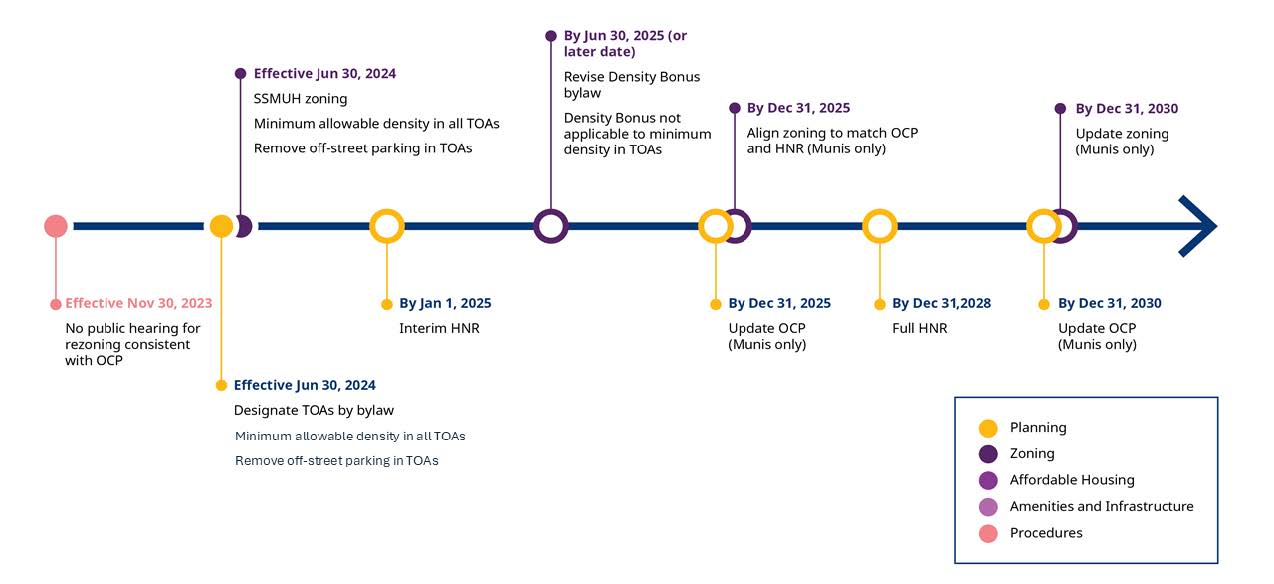
Implementation Timeline
The following timeline highlights key deadlines, summarizing important dates for aligning HNRs, OCPs, and zoning bylaws.
Integration with Other Local Government Housing Initiatives
The proactive planning measures introduced in the Fall of 2023 are components of a broader suite of changes to the local government land use planning framework. These changes are designed to complement and work together to enable local governments to provide more housing, in the right places, faster.
Key pieces of legislation that will interact with the proactive planning framework include:
- Small-Scale Multi-Unit Housing (SSMUH): required local governments to update their zoning bylaws by June 30, 2024, to permit SSMUH development in land use zones that are otherwise restricted to single-family dwellings or duplexes. In most urban areas, depending on lot size and proximity to transit, the new SSMUH zoning requirement allows 3 to 6 units per lot in these zones, with some exceptions. Outside of urban areas, a minimum of either a secondary suite or detached additional dwelling unit must be permitted, with exceptions. These changes aim to enable greater housing density and offer a range of housing options (e.g., secondary suites/accessory dwelling units, triplexes, and townhomes), supporting local governments in meeting their 20-year zoning requirements. More details are provided in the SSMUH Provincial Policy Manual and Site Standards.
- Transit-Oriented Areas (TOAs): required some municipalities to designate TOAs by bylaw within 800 metres of rapid transit stations and 400 metres of bus exchanges and West Coast Express stations that are listed in the Regulations by June 30, 2024. Within TOAs, municipalities cannot reject rezoning applications that propose a level of density or height that is at or below the minimums established by the Province based on density and height alone. While there is no requirement for TOAs to be pre-zoned, some municipalities may choose to pre-zone these areas, in part or whole, to facilitate development. More details on how this may interact with proactive planning requirements are available in the Calculating Zoning Capacity to align with HNRs section. More details are provided in the Transit Oriented Areas Provincial Policy Manual.
- New and Expanded Development Finance Tools: provide updates to existing Development Cost Charges (DCCs) to include new categories such as fire protection, police, and solid waste and recycling facilities, in addition to the existing ability to collect funds for sewage, water, drainage, highway facilities, and the acquisition and improvement of parkland. The new Amenity Cost Charge (ACC) tool enables local governments to collect funds for amenities like community centres, libraries, and daycares from new developments that result in increased demand for services. These updated tools are essential for financing the infrastructure and amenities related to growth that are required to support complete and livable communities. The Development Cost Charge Best Practices Guide and Amenity Cost Charge Best Practices Guide provide more detail for local governments seeking to develop or update bylaws.
- Additional tools for complete communities: clarified and expanded existing powers available to local governments to secure key outcomes related to affordability and complete communities. Specifically, these authorities relate to: inclusionary zoning, density bonus, tenant protection, site-level infrastructure (including works and services and requiring additional land for transportation infrastructure), and transportation demand management. For more information, visit the New Local Government Tools webpage.
Housing Needs Reports
Part 14, Division 22 of the Local Government Act (LGA) along with the Housing Needs Report Regulation provides the updated legislative requirements and timing for HNRs, which includes the requirement to use a standard methodology (the HNR Method) to support more robust, consistent and comparable understandings of local housing needs.
The timing of HNRs now follow each census data release, which helps ensure all reports are based on the most up-to-date information and that other, non-census-based datasets are collected around the same time, improving comparability.
The summary below provides a high-level HNR overview. For comprehensive guidance, including detailed legislative and regulatory requirements, technical guidance to calculate the HNR Method, FAQs, and link to the BC Data Catalogue and the HNR calculator, please visit Housing Needs Reports – Province of British Columbia (gov.bc.ca)
Interim Housing Needs Reports
By January 1, 2025, all local government councils and boards must have received Interim HNRs and published them online on an internet site that is publicly and freely accessible.
The Interim HNR has three new, additional content requirements:
- The number of housing units required to meet current and anticipated needs for the next five and 20 years (calculated using the standardized HNR Method);
- A statement about the need for housing in close proximity to transportation infrastructure that supports walking, bicycling, public transit or other alternative forms of transportation; and
- A description of the actions taken by the local government to reduce housing needs since the most recent HNR.
After the Interim HNR, municipalities will have until December 31, 2025, to complete their first OCP and zoning bylaw updates to allow (plan and 'pre-zone') for the number of units identified in the Interim HNR.
Regional districts are not required to update their OCPs and zoning bylaws by December 31, 2025; however, future OCP updates must align with the most recent HNRs, including incorporating housing policies respecting each class of housing needs.
Regular Housing Needs Reports
The first 'regular' HNR must be completed and received by December 31, 2028, and every five years thereafter. Regular HNRs must include the following content:
- the number of housing units needed over the next five-and 20-year period, as calculated using the HNR Method;
- statements about the seven classes of housing needs (listed here);
- the number and percentage of households in core housing need and extreme core housing need; and
- a description of housing actions and changes in housing need since the last HNR.
Regional districts must include this required content for each electoral area (except those that are exempt).
For full details, refer to the Summary of Legislative and Regulatory Requirements for Housing Needs Reports.
The HNR Method
The HNR Method calculates the total number of housing units needed over five and 20 years. It consists of six components, which are added together to provide the total number of housing units needed in a municipality or regional district electoral area. The six components include:
- Supply of units to reduce extreme core housing need (those paying more than 50% of income for housing);
- Supply of units to reduce homelessness;
- Supply of units to address suppressed household formation;
- Supply of units needed to meet household growth over the next five or 20 years;
- Supply of units needed to meet at least a 3% vacancy rate; and
- Supply of units needed to meet local demand (the "demand buffer").
The "Demand Buffer"
Also known as the Demand Factor, this component helps ensure that in calculating the total number of housing units needed over 5 and 20 years, the HNR Method accounts for the units required to meet "healthy" market demand, beyond the minimum required to house current and anticipated residents.
It is only included in the calculation for municipalities.
The demand buffer helps reduce pressure in the housing system and ensures the market can meet the needs of diverse groups, including growing families seeking larger homes, seniors downsizing, and households wanting to reduce their commute and live closer to jobs or schools.
To support local governments in applying the HNR Method, UBC's HART team released the HNR calculator in July 2024. The HNR Calculator's data is current to the application of the Interim HNR. The HNR Method Technical Guidance provides more information, as well as step-by-step instructions for those wishing to apply the HNR Method using Microsoft Excel.
HNRs and Housing Targets: What is the difference?
HNRs and Housing Targets serve different purposes for addressing housing need in BC. Although the two methods were co-developed to ensure consistency, there are several distinctions. The HNR Method calculates the total number of housing units required to meet unmet needs, current demand, and anticipated growth over both a 5-year and a 20-year period, whereas Housing Targets focus exclusively on the 5-year current and anticipated needs and set a minimum compliance threshold of 75%. Additionally, to comply with the Housing Supply Act, Housing Targets are aimed at a smaller set of communities facing particularly significant housing challenges, while HNRs are required for all local governments.
NOTE: A municipality's OCP and zoning bylaw must align with their most recent HNRs to demonstrate capacity to accommodate the 20-year HNR unit number, however the 20-year unit numbers are not targets and do not set a requirement to build or report on construction of these units.
Aligning OCPs and Housing Needs Reports
An OCP sets out a long-term vision for the future, including broad goals and policies for land use, transportation, housing, economic development, recreation, the environment, and community services. OCPs use land use designations (e.g., residential, commercial, industrial) to define the intended use of land. The shift to a more proactive planning framework continues to rely on OCPs to guide community growth, with a greater emphasis on ensuring adequate density for new housing development.
The details about OCPs and HNRs as outlined in Part 14, Division 4 – Official Community Plans of the Local Government Act are summarized below.
OCP Requirements for All Local Governments
When developing or updating an OCP, all local governments (including municipalities, regional districts, or local trust committees) are required to consider the most recent HNR and the data that support it to ensure the OCP reflects current housing needs and trends (LGA s. 473.1 (2)). Additionally, when developed or amended, all OCPs must include:
- Statements and map designations for the approximate location, amount, type, and density of residential development needed for at least the next 20 years (LGA s. 473 (1) (a)).
- Housing policies that address each class of housing need (HNRR: Section 8 (1) (b)) included in the most recent HNR (LGA s. 473.1 (4)):
- Affordable housing
- Rental housing
- Special needs housing
- Seniors' housing
- Family housing
- Shelters for individuals experiencing homelessness and housing for individuals at risk of homelessness
- Housing in close proximity to transportation infrastructure that supports walking, bicycling, public transit or other alternative forms of transportation
OCP Housing Policies
Local governments must ensure their OCP includes policies that address each of the seven classes of housing need listed above. There is flexibility in how such policies are structured – multiple policies can address a single class of housing need, and a single policy can apply to multiple classes of housing need. Beyond the seven specified classes, local governments may also want to include policies addressing other types of local housing need.
Additional OCP Requirements for Municipalities
In addition to the requirements detailed above, there are additional requirements for municipalities, which do not apply to regional districts and local trust committees:
- OCPs are now mandatory for municipalities. Previously, local governments could choose whether to adopt an OCP, although almost all local governments did so. (LGA s. 472 (1.1))
- OCPs must be updated regularly after HNRs. The first OCP update is due December 31, 2025, and then every five years (i.e. December 31, 2030, 2035, and beyond). (LGA s. 473.1 (5) and HNRR s. 14)
- Alignment requirement with HNRs. Municipalities must ensure OCP statements and map designations provide for at least the 20-year total number of housing units identified in the most recent HNR. (LGA s. 473.1 (3))
- Zoning bylaws must be reviewed and updated to align with OCP. Municipalities must also ensure that zoning bylaws permit the necessary land use and density to meet the 20-year housing as identified in the OCP. This is detailed in the section below. (LGA s. 481.7 (1) and (2)).
A key reason for limiting these requirements to municipalities is to help limit sprawl and focus development to existing urban areas, which are more likely to have established infrastructure and services and less exposure to hazards compared to the largely rural electoral areas within regional districts.
Going Beyond Minimum Requirements
New or updated municipal OCPs must comply with the new legislative requirements, as detailed above. However, for some local governments there may be value in going beyond minimum requirements to help plan for and support the delivery of both the housing that addresses specific local housing needs, as well as all of the complementary land use, amenities, services, and infrastructure required for complete communities. Examples of how this can be achieved include:
- Statements, map designations, and the designation of land and densities exceeding the mandatory 20-year minimum housing units identified in the HNR. This may be particularly relevant for municipalities where the 20-year capacity may already be initially addressed through zoning for SSMUH. Expanding the range of potential sites for different types of housing can:
- Increase the supply of rental, co-op and non-market housing. Consider broad pre-zoning for low-rise rental housing (e.g. small apartments) and/or non-market housing. This approach, which some BC local governments have already implemented, supports project viability for rental, co-op and non-market housing developers, by creating more streamlined approval pathways, saving time and money, and reducing risk.
- Facilitate the development of complete communities. Provide opportunities for diverse housing types in locations that align with amenities, services, and transit.
- Outlining the core elements of an affordable housing strategy. Consider describing the broad approach to securing affordable, special needs, rental or other types of housing, including through tools such as inclusionary zoning, density bonus zoning, and residential rental tenure zoning (often referred to as "rental zoning").
- Incorporating additional measures to support complete communities: Include updated information in OCPs around expanded works and services and sustainable transportation infrastructure. This includes policies about alternative forms of transportation and transportation demand management (LGA s. 474 (1). More information is available on the New Local Government Tools webpage.
Aligning Zoning Bylaws and Housing Needs Reports
OCPs outline the long-term vision for communities, setting broad policy goals and designating land use categories (e.g., residential, commercial, industrial) that define the intended use of land. While these designations guide future growth, zoning bylaws are the tools that implement the land use visions of OCPs by regulating how land, buildings, and structures may be used.
In the past, zoning bylaws were often not updated to align with OCPs. As a result, changes to land use, even when desired by local governments and supported by the broader community during OCP development, were often subject to lengthy and expensive site-specific rezoning processes.
To address these challenges, municipalities must review, and, if necessary, adopt a zoning bylaw to permit the necessary use and density to accommodate at least the 20-year total number of housing units identified in the most recent HNR (LGA s. 481.7 (1) and (2)).
Calculating Zoning Capacity to Align with HNRs
While the LGA requires that the OCP and Zoning Bylaws of a municipality must provide for at least the 20-year total number of housing units required to meet anticipated housing needs, the LGA does not prescribe a method for calculating zoned housing capacity.
This section offers suggested best practices for municipalities to effectively zone for their 20-year housing needs, however, municipalities have the flexibility to identify their own methods and to determine where density is best located in their communities, while also considering future growth beyond the 20-year number.
Some important considerations when updating zoning bylaws to meet the 20-year total number of units identified in the HNR:
- Integration with SSMUH legislation: Municipalities should consider how much zoned capacity has been created by recent amendments to accommodate SSMUH legislation requirements. For some communities, the enabling of SSMUH may satisfy the identified 20-year unit number for the first (or even second) round of required OCP and zoning bylaw updates. However, since SSMUH is focused on relatively lower-density forms of housing, pre-zoning for higher-density housing (e.g. small apartments) might help address a community's need for a range of housing types and densities.
- Density Bonusing is excluded: In calculating zoned capacity, only the "base" density should be considered. Any "bonus" density, which is subject to conditions, must be excluded. This approach ensures that the zoned capacity analysis reflects a more realistic understanding of what new housing can be most easily developed (i.e. closer to "outright" zoning). (LGA s. 481.8)
- Transit-Oriented Areas: While the minimum allowable density framework established by the Province is in effect within TOAs, the minimum densities and heights do not automatically contribute to the zoned capacity requirements on their own. For such areas to "count" towards meeting the zoned capacity requirement, a municipality would need to take the additional step of pre-zoning them. TOAs are logical places to focus growth, and municipalities should consider where within TOAs it is most advantageous to pre-zone.
Calculating Maximum Potential Zoned Capacity
The information included in this section has been excerpted from the Provincial Policy Manual & Site Standards: Small-Scale, Multi-Unit Housing (gov.bc.ca) – Appendix D (page 86) and adapted for this guide to provide an overview of zoning best practices. While municipalities have the flexibility to develop their own approaches and determine the most suitable locations for density, the following method offers guidance on calculating density distribution based on HNRs.
- A simple approach to determining the maximum potential zoned capacity is multiplying the number of lots in each zoned category by the number of dwelling units permitted in that category, and then totaling the numbers for all categories. Examples are provided below:
- If there are 262 properties whose zoning bylaws permit at least four dwelling units per lot, then the maximum build-out of this zoning category is 1,048 (262 properties × 4 units).
- If there are 150 properties zoned for low-rise apartments with a maximum allowable density of 12 dwelling units per property, then the maximum build-out of this zoning category is 1,800 (150 properties × 12 units).
- If there are 75 properties zoned for mid-rise apartments with a maximum allowable density of 40 dwelling units per property, then the maximum build-out of this zoning category is 3,000 (75 properties × 40 units).
- If there are 50 properties zoned for high-rise apartments with a maximum allowable density of 100 dwelling units per property, then the maximum build-out of this zoning category is 5,000 (50 properties × 100 units).
Determining the maximum net increase in units, however, requires an extra step to align the unit calculations from the maximum build-out, to count against the existing units (the homes that currently exist within those zones). This second step can be completed by using data from either the most recent Statistics Canada Census or BC Assessment.
Approaches using both data sets are outlined below:
Method 1 – BC Assessment approach
- BC Assessment (BCA) produces a standard yearly digital dataset called the BC Building Information Report. This report is available to all local and regional governments from BCA free of charge.
- This report can be structured to indicate the number of units at the parcel scale. This can be achieved by identifying all parcels with single detached actual use codes and assigning them a value of 1 and all parcels with secondary suite actual use codes and assigning them a value of 2.
- Net increase in units can be calculated by using the selections and totals generated in the section above less the values determined in step b above. These increases can be used at the disaggregated level or summarized to the municipal level as appropriate.
Method 2 – Census data approach
While lacking in spatial specificity, this technique can be used to rapidly determine the net increase in units against a 2021 baseline through the steps below:
- An individual jurisdiction's Census Profile can be accessed through Statistics Canada. This profile contains the number of dwelling units by jurisdiction.
- Total increases in units can be determined by deducting the Census value from the totals determined in the maximum build out density.
From Theoretical Capacity to Realistic Uptake: Calculating incremental build-out density of pre-zoning
Note: this information was originally developed for the Provincial Policy Manual & Site Standards: Small-Scale, Multi-Unit Housing (gov.bc.ca), Appendix E, page 89. The information has been excerpted and adapted for this guide (Please see the Appendix for additional information):
While calculating the maximum potential zoned capacity, also known as the "paper" capacity, provides an essential baseline for understanding how many housing units could theoretically be developed, it is important to assess the realistic uptake. The "paper" capacity often represents an ideal scenario, but in practice, various factors such as market demand, infrastructure constraints, and economic conditions will influence how much of this capacity will actually be useable. Municipalities should consider these real-world factors to ensure that their planning efforts are aligned with actual development patterns and community needs.
The following section summarizes two suggested methods to consider how the paper capacity will align with actual uptake.
Method 1: Trends Assessment
This simpler approach relies on historical data from the Census and BC Assessment (BCA) to estimate development uptake under various scenarios. By analyzing trends in dwelling types and growth patterns, municipalities can develop annual absorption rates and adjust for market conditions, infrastructure, and other factors to project realistic future development.
Method 2: Complex Build-Out Modeling
This advanced method involves detailed data analysis, including geospatial and numerical modeling, to create sophisticated development scenarios. This approach requires input from GIS experts and land economists to model redevelopment potential, considering zoning, market conditions, and constraints. The result is a highly accurate build-out model that forecasts community development over a 20-year period.
Changes to Public Hearings
A Shift Towards Upfront Engagement
The proactive planning framework marks a shift from the previous approach to housing planning and approvals, which relied on individual rezoning processes and community engagement for each site. The new framework focuses on long-term planning to ensure sufficient land is designated and pre-zoned for current and future housing needs, streamlining projects by avoiding time-consuming, costly, and uncertain rezoning processes.
A key part of this shift involves early and upfront public consultation to plan for new housing. This consultation needs to happen before the OCP is updated and must meet legislative requirements outlined in LGA s. 475, including a public hearing (LGA s. 477 (3) (c)). OCP processes typically provide more opportunities for engagement and input than rezoning processes and allow for residents to better understand how much and what kinds of additional housing are needed.
This proactive, upfront approach is designed to gather and consider community input earlier in the process. Consequently, once an OCP is updated, a local government cannot hold a public hearing if a proposed zoning bylaw (rezoning) for a housing project aligns with the OCP (LGA s. 464 (2)).
For such OCP-consistent zoning bylaws, the legislation does not require local governments to announce that there is no public hearing being held; however, the local government will need to issue a public notice (LGA s. 467) that the zoning bylaw is moving through the approval process. Local governments can still opt-in to public hearings for OCP-consistent rezonings for non-residential land uses (e.g., commercial, industrial).
Best Practices and Considerations
Beyond the legislated requirements, there are a range of best practices that local governments can adopt to enhance their proactive planning efforts.
Complete Communities
The Complete Communities Guide serves as a best practice resource, offering a comprehensive approach to integrating housing, daily needs, transportation, and infrastructure to build more resilient communities. This approach supports the proactive planning approach, helping local governments achieve their community development goals effectively.
Complete communities provide a diversity of housing to meet identified community needs and accommodate people at all stages of life, and provide a wider range of employment opportunities, amenities, and services within a 15- to 20-minute walk. Complete communities can be more efficient to service with infrastructure and have the potential to reduce community greenhouse gas (GHG) emissions associated with transportation.
Creating more complete communities can support a range of identified community goals and offer many interrelated benefits, including (but not limited to):
- More housing and transportation options.
- Increased walkability, accessibility, age-friendliness, and equity.
- Greater efficiency with servicing and infrastructure.
- Environmental sustainability, including reduced GHG emissions, largely from focusing on public and active transportation.
- Preservation of the natural environment by reducing sprawl.
More information, including the Complete Communities Guide is available on the Complete Communities webpage.
First Nations Engagement
When updating OCPs, local governments should engage with First Nations through collaboration and proactive communication, fostering government-to-government relationships. These efforts contribute to inclusive decision-making and support reconciliation in BC.
Local governments are encouraged to incorporate the United Nations Declaration on the Rights of Indigenous Peoples (UNDRIP) and the Declaration on the Rights of Indigenous Peoples Act in their planning processes.
For more guidance, visit: Local government and First Nations relations – Province of British Columbia.
The Indigenous Housing Needs Data Resource Library, created by the Aboriginal Housing Management Association, provides key data points and direct links to resources that can help local governments assess housing needs and vulnerabilities within Indigenous communities. Access the Indigenous Housing Needs Data Resource Library – Aboriginal Housing Management Association.
PlanningTogetherBC: Integrating Land Use and Transportation Planning for Thriving Communities
PlanningTogetherBC is an integrated planning framework that seeks to align transportation and land use planning for smart and coordinated growth in British Columbia. The integration of transportation and land use planning can achieve more affordable communities, offer better housing options, increase economic opportunities, provide more sustainable transportation options, reduce GHG emissions, and result in more resilient communities.
OCPs describe the location and degree of future growth within a local government's jurisdiction, suggesting where development and traffic patterns may change over time and providing insights as to where multi-modal transportation investments may be needed to support growth. The transportation section of an OCP typically outlines a community's policies, plans and priorities for transportation such as future transit routes, arterial widening, and active transportation routes. The integrated planning framework allows decision-makers to see how population growth, housing supply, transportation and utility infrastructure are connected within a complete system.
Local governments are encouraged to engage with the Ministry of Transportation and Transit early in their planning processes, particularly in situations where growth is being located near a controlled access highway. A coordinated cross-jurisdictional approach to planning will enable transportation investments and land use decisions to create complete communities that are healthy, affordable and resilient.
For more information on Integrated Planning at the Ministry of Transportation and Transit, please visit: https://www2.gov.bc.ca/gov/content/transportation/transportation-infrastructure/transportation-planning/planningtogetherbc.
Heritage Conservation Act
The Heritage Conservation Act (HCA) encourages and facilitates the protection and conservation of BC's unique cultural heritage. Archaeological sites are granted automatic protection through section 12.1 of the HCA and are afforded protection whether they are recorded or as-yet unrecorded, located on public or private land, and whether they are intact or disturbed.
Local governments play an important heritage conservation role, and when undertaking infrastructure improvements, maintenance or other land altering activities, they are responsible for avoiding or mitigating impacts to protected sites. Local governments can also inform citizens of their responsibilities under the HCA and may act as proponents responsible for ensuring development projects have appropriate studies and permits.
The BC Archaeology Branch (Archaeology Branch) recommends local governments include information regarding archaeological site management in their OCPs to help landowners and developers understand their responsibilities surrounding provincially protected archaeological sites. Entities who proceed with development and encounter a heritage object or site protected under the HCA during land altering activities must stop work immediately and cease work until appropriate HCA permits are in place.
For further information, local governments can contact the Permit Connect team to better understand provincial permitting requirements. More information is available at: https://permitconnectbc.gov.bc.ca.
Mass Timber
Mass timber is at the forefront of construction innovation. Mass timber offers a sustainable, low-carbon alternative to concrete and steel, while minimizing disruption to local communities. As a renewable material, it generates 25%–40% fewer GHG emissions over a building's lifecycle, helping local governments achieve their climate and sustainability goals.
Created by bonding smaller pieces of wood into large structural components, mass timber is precision-cut off-site and arrives ready for installation. This allows buildings to be erected up to 30% faster than concrete and steel with a smaller crew – reducing congestion, noise, waste disposal, and pollution in surrounding neighborhoods.
To reach our climate, housing, and economic goals, building construction needs to speed up, control costs, and streamline. Municipalities can take proactive steps to make it easier to build with mass timber, such as:
- Incorporate mass timber-friendly design allowances in OCPs, including possible exceptions for setbacks and podium design guidelines.
- Zone for medium-rise construction (7 to 18 stories), the optimal height range where residential mass timber is most competitive over alternative materials.
- Amend zoning bylaws to accommodate thicker mass timber floor assemblies – allowing for six additional inches per floor or 10% greater total building height.
- Encourage early collaboration between building officials and design teams to ensure a smooth permitting process.
- Issue early permits for structural shells and/or excavation, allowing off-site manufacturing to begin sooner and accelerating project timelines.
For more detailed information, visit SFU Renewable Cities Local Prefab Mass Timber Solutions or contact the Office of Mass Timber Implementation.
More Information
The content of this guide is not a substitute for legislation, nor should it be relied upon as legal advice. Users of this guide should seek legal advice, as necessary. To help facilitate implementation of these changes, the Province will continue to update guidance and FAQs to support local governments.
More information on local government housing initiatives is available on the Ministry of Housing and Municipal Affairs website at: https://www.gov.bc.ca/housingInitiatives
Please direct any questions about this legislation to:
Ministry of Housing and Municipal Affairs,
Planning and Land Use Management Branch
Email: PLUM@gov.bc.ca
Appendix: From Theoretical Capacity to Realistic Uptake – Calculating incremental build-out density of pre-zoning
Note: this information was originally developed for the Provincial Policy Manual & Site Standards: Small-Scale, Multi-Unit Housing (gov.bc.ca), Appendix E, page 89 and has been excerpted and adapted for this guide.
Method 1: Trends assessment – a simpler approach
The trends assessment approach is a basic method that uses readily available data to build assumptions about the development uptake of units under multiple scenarios. The informational basis for this approach is tied to longitudinal information from either the Statistics Canada Census or BC Assessment (BCA) data, whichever is more readily available.
| 1. | Data development: detailed information with regards to the growth in dwellings across different zones is available from either the Census of Canada or BCA. Each of these datasets can be structured to build assessments in the following ways. | |
| a. | Census data: Census profiles from 2006, 2016, and 2021 can each be accessed from Statistics Canada for any given local government. Each of these profiles will contain a report on the quantity of dwellings unit by structural type of dwelling2. This information can be reviewed and categorized to correspond to specific zoning designations, for example:
|
|
| Each of these above dwelling types can be summarized longitudinally in order to build basic annual absorption rates by dwelling type. | ||
| b. | Assessment data: BC assessment data contains information on the quantity and type of buildings based on their year of construction. For the purposes of this exercise, it is necessary to discern how many units by type are constructed each year. This can be done by using BCA's Actual Use Code (AUC) and the BCA "year built" fields. Pertinent actual use codes could include:
|
|
| Like the Census method above, each of the above unit types can be summarized from 2006 in order to build basic annual absorption rates by unit types. | ||
| 2. | Assumptions development: given the data developed above, the following assumptions should be generated: | |
| a. | Historic absorption rates by unit type → Summarize units and divide by 15 (regardless of method), this is the basic annual absorption rate | |
| b. | Unit growth factor → a percent modification based on a considered review of market conditions to determine the increase in annual absorption over the baseline rate detailed above. | |
| c. | Other absorption rate assumptions → additional constraining factors such permitting times, escalating costs, declining provincial growth that can modify the growth factors detailed above. | |
| d. | Infrastructure and servicing assumptions → constraining factors as they relate to increased servicing requirements that may mitigate against the development of certain unit types. | |
| 3. | Current state development: based on calculations described above, the current state of units can be used to net out the incremental increase in units based on the trends to be calculated in step five (5) below. | |
| 4. | Maximum possible capacity analysis: the maximum unit capacity should be determined to construct a maximum bound for the trend to be calculated in step five (5) below. | |
| 5. | Trend assessment: using the information from steps 1 and 2, growth rates should be developed that reflect historic trends and mitigating factors. Growth rates should not exceed the maximum capacity of units in step four (4), nor should they be so extreme as to double or triple the number of units within a 20-year time frame. | |
| 6. | Buildout modeling: growth rates should be transformed into annual absorption rates to determine the net annual number of units that may be constructed over time. This incremental increase in capacity can be subsequently used to inform infrastructure considerations which are discussed in Part 3, Section 6 of the Provincial Policy Manual & Site Standards: Small-Scale, Multi-Unit Housing (gov.bc.ca). | |
2 https://www12.statcan.gc.ca/census-recensement/2021/ref/98-500/001/98-500-x2021001-eng.cfm
3 Note that detached coach homes are treated as single detached dwellings and are therefore challenging to isolate from that grouping.
Method 2: Complex Build-Out Modeling
The complex build-out modeling approach is an advanced method that uses readily available data to construct likely development scenarios under current economic conditions. This approach should be led by a qualified GIS expert in conjunction with a land economist and local government staff, including development planners and long-range planners. The effort requires significant levels of data structuring and advanced geospatial and numerical modeling. Despite its complexities, this approach will yield highly accurate results that can be used for infrastructure impact analyses and other value-added analyses as appropriate. Each step of this method is detailed below.
1. Data Development
Data to be considered for this effort should include BCA data, BIR data, as well as any information regarding conceptual, proposed, or in-progress developments, environmental or infrastructural constraints to development, along with local government policies and regulations pertaining to allowable uses, density, and built forms. Subsequently, the BCA data should be processed such that a reasonable baseline of buildings in the community can be developed at the parcel scale.
This baseline will include information on the use of each parcel, the assessment classification code and occupancy code of the parcel, the number of units, the construction year of the structures, the total built floor area, and the total land and improvement values. In addition, relevant municipal policy information, development permit data, and constraints data should be extracted and applied to the parcels.
The outcome of this process will be a fully attributed baseline dataset that presents an up-to-date snapshot of all development considerations in the community at the parcel scale. This data can be used for value-added purposes in any current-state-style assessment. This information will be used to determine the potential for a parcel to redevelop under normal economic conditions.
2. Assumptions Development
Given the zoning bylaws that suggest a discrete potential development typology for any given parcel, it is crucial to develop a representative set of modeling archetypes, each of which will act as parametric guidelines in the modeling. The archetypes will have two major components:
- Built Form Assumptions – These are the design considerations that will guide the minimum parcel size, minimum floor-plate size, density, height, setback, and usage of a particular development. They are crucial for determining the economic viability of a potential use as well as the resulting form. The key components include density, coupled with maximum or achievable FARs (Floor Area Ratios) and setbacks, all of which may impact the ultimate built form of the location, the total potential floor area of the development, and the resulting potential hypothetical profit of the development given the input land and construction costs.
- Development Context Assumptions – These assumptions relate to the contextual milieu by which a particular building type will be permitted. Typically, this forms a table of allowed uses by land use type and local plan area, but occasionally additional overlays are considered, such as development permit areas, location-specific overrides, or other policy considerations (such as agricultural interface), on a case-by-case basis.
Secondly, absorption rate scenarios should be developed. These will be used to determine the cadence of development once redevelopment potential is evaluated. This will require the following efforts:
- Analysis of the municipality's recent development history
- Interviews with municipal staff
- Interviews with local builders and developers
- Analysis and projections of the region's relevant labor force
These inputs will be refined into 2 to 3 scenarios which will define the cadence and volume of development in the community from the near term (3 years out) to 20 years. As these scenarios could have a significant impact on how the community will build out, they should be tested for realism and require both input and sign-off by relevant municipal planning and engineering staff in advance of finalization.
3. Current State Development
Using the information developed in Step 1 above, it is imperative to score all qualifying parcels in the community to determine how the urban fabric may change over time. This effort is required to add a degree of realism to this incremental build-out effort and should be used to evaluate development potential, which reflects a market response to zoning policy, land availability and costs, housing and employment demands, access to transit, as well as locational contexts more generally.
The core of this modeling step is to establish a "redevelopment" score for a given location. To establish development likelihood scores, a modeling team should consider some combination of the following market factors:
- Parcel improvement value to land value ratio: This ratio is developed by dividing a parcel's improvement value by its land value. A parcel with a low improvement-to-land ratio is more likely to be redeveloped.
- Average adjacent parcel improvement value to land value ratio: A parcel with a low improvement-to-land ratio compared to its neighbor's is more likely to be developed.
- Parcel FAR: Floor area ratio (FAR) is the measure of the built floor area of a parcel divided by the total area of the parcel. A parcel with a low FAR is more likely to be developed.
- Density Gap: This measure evaluates the relative utilization of parcels under current policy. A parcel with a large density gap is more likely to be developed.
- Effective Year: This factor considers renovations and upgrades of a structure which serves as a better metric than year built. Generally, a parcel with an older effective year is more likely to be developed.
- Locational factors: As appropriate for higher densities, it may be appropriate to allocate an additional locational bonus to reflect favorable contexts for some developments (specifically transit station areas).
Regardless of the factors used, the second stage of this step is to reduce or constrain the development potential of a given location using a standard set of constraints (potentially including, but not limited to flood plains, hazardous/complex terrain, potentially contaminated sites, locations of indigenous cultural significance, interface considerations, etc.), which should act in three separate ways:
- The first should be to reduce the development potential score of some sites on a case-by-case basis with input from the development planners in the community.
- The second application of constraints should be to reduce the functional size of some parcels. This should occur mainly through environmental constraints, encumbrances, and other infrastructure requirements.
- The third should be to remove some parcels from consideration entirely. This should incorporate development planners' collective knowledge and should be evaluated on a parcel-by-parcel basis and may include rental housing stock retention and/or land ownership, as appropriate.
The final stage of the redevelopment model is to score all parcels based on the net of redevelopment potential and constraints. Scores are typically assigned at a sub-municipal level either by policy context, location context, or some combination thereof. This is done by design since developing a comprehensive municipal score comparing lower-value outlying parcels and higher-value inner-city parcels does not yield useful information.
4. Maximum Possible Capacity Analysis
As detailed in earlier calculations in the section above, the maximum unit capacity should be determined to construct a maximum bound for the trend to be calculated in Step 5 below.
5. Development Likelihood Analysis
Once the redevelopment potential has been quantified and the development archetypes have been defined, intermediate processing of all parcels in the community should be conducted to determine which development archetype would work best on a site-by-site basis. These efforts should include:
- Removal of newly developed, to-be-developed, illogical, or highly constrained parcels from the model
- Testing all parcels for qualifying development typologies using built-form, policy, and economics inputs as a guide to identify the most profitable (and/or viable) potential development typologies. For instance, in an area that allows for up to six units, due to increased construction costs, the most profitable development type for this parcel may be a four-plex as opposed to a six-plex.
6. Build-Out Modeling
Steps 1 to 5 above will result in a preferred potential development outcome for each parcel in the community that has development potential. Theoretically, this outcome represents the maximum logical capacity of a community absent any considerations regarding unit absorption rates (i.e., the rate at which units sell in an area in a given time period), permitting speeds, or labor considerations. To refine this maximum capacity into a reasonable sequence of development, it is therefore necessary to apply the absorption rate scenarios as defined in Step 2 above to the preferential development outcomes in Step 5 to develop an annual build-out of the community over a 20-year period. This will result in a numerical build-out that indicates for each qualifying zoned parcel, the potential year of development, the resulting development type, floor area, and number of units.
These units can subsequently be converted into population or equivalent development units (EDUs) as appropriate for the local government's needs using agreed-upon multipliers (either from standard BC best practices or using trended municipal data or a combination of both). Summary data can be produced for milestone years, as appropriate, and should be accompanied by maps and graphs for rapid review and iteration.
The technical work should be finalized based on clear acceptance criteria from a local government that should be developed during project initiation. Specific criteria could include, but may not be limited to:
- Accuracy: Does the build-out reflect the policy input parameters of the modeling? Do the build-outs indicate a smooth development cadence that mirrors historic trends?
- Realism: Does the build-out reflect the experience of municipal staff with respect to historic development in the community?
- Plausibility: Does the build-out portray development outcomes that seem achievable under current or forecast economic conditions?
- Spatial Distribution: Does the build-out indicate a spatial pattern of development that reflects the intents of municipal planners?